GIS and OS Tiles
StatMap
https://intranet.kingston.gov.uk/task/map-gallery/#chapter_head
https://intranet.sutton.gov.uk/task/map-gallery/#chapter_head
GIS Manager for Street Gazetteer
OS Tiles
Kingston:
Kingston OS Tiles dwg files are saved as unitless
X:\Autocad_library\RBK CAD Library\CAD Library\RBK OS Maps 2022
TQ1558, TQ1559, TQ1560, TQ1561, TQ1562, TQ1563, TQ1564, TQ1565, TQ1566, TQ1567, TQ1658, TQ1659, TQ1660, TQ1661, TQ1662, TQ1663, TQ1664, TQ1665, TQ1666, TQ1667, TQ1668, TQ1669, TQ1670, TQ1671, TQ1672, TQ1758, TQ1759, TQ1760, TQ1761, TQ1762, TQ1763, TQ1764, TQ1765, TQ1766, TQ1767, TQ1768, TQ1769, TQ1770, TQ1771, TQ1772, TQ1858, TQ1859, TQ1860, TQ1861, TQ1862, TQ1863, TQ1864, TQ1865, TQ1866, TQ1867, TQ1868, TQ1869, TQ1870, TQ1871, TQ1872, TQ1958, TQ1959, TQ1960, TQ1961, TQ1962, TQ1963, TQ1964.1, TQ1964, TQ1965, TQ1966, TQ1967, TQ1968, TQ1969, TQ1970, TQ1971, TQ1972, TQ2062, TQ2063, TQ2064, TQ2065, TQ2066, TQ2067, TQ2068, TQ2069, TQ2070, TQ2071, TQ2072, TQ2073, TQ2163, TQ2164, TQ2165, TQ2166, TQ2167, TQ2168, TQ2169, TQ2170, TQ2171, TQ2172, TQ2173, TQ2263, TQ2264, TQ2265, TQ2267, TQ2268, TQ2269, TQ2270, TQ2271, TQ2272, TQ2273, TQ2363, TQ2364, TQ2365, TQ2366, TQ2367, TQ2368, TQ2369, TQ2370, TQ2371, TQ2372, TQ2266
Sutton:
X:\Autocad_library\RBK CAD Library\CAD Library\Sutton OS Maps 2022
TQ2161, TQ2162, TQ2163, TQ2164, TQ2165, TQ2166, TQ2167, TQ2168, TQ2260, TQ2261, TQ2262, TQ2263, TQ2264, TQ2265, TQ2266, TQ2267, TQ2268, TQ2360, TQ2361, TQ2362, TQ2363, TQ2364, TQ2365, TQ2366, TQ2367, TQ2368, TQ2460, TQ2461, TQ2462, TQ2463, TQ2464, TQ2465, TQ2466, TQ2467, TQ2468, TQ2559, TQ2561, TQ2562, TQ2563, TQ2564, TQ2565, TQ2566, TQ2567, TQ2568, TQ2659, TQ2660, TQ2661, TQ2662, TQ2663, TQ2664, TQ2665, TQ2666, TQ2667, TQ2668, TQ2758, TQ2759, TQ2760, TQ2761, TQ2762, TQ2763, TQ2764, TQ2765, TQ2766, TQ2767, TQ2768, TQ2858, TQ2859, TQ2860, TQ2861, TQ2862, TQ2863, TQ2864, TQ2865, TQ2867, TQ2868, TQ2958, TQ2959, TQ2960, TQ2961, TQ2962, TQ2963, TQ2964, TQ2965, TQ2966, TQ2967, TQ2968, TQ3060, TQ3061, TQ3062, TQ3063, TQ3064, TQ3065, TQ3066, TQ3067, TQ3068, TQ3160, TQ3161, TQ3162, TQ3163, TQ3164, TQ3165, TQ3166, TQ3167, TQ3261, TQ3262, TQ3263, TQ2560, TQ2866
Projects
Cagla
Banstead Road South Zebra
Folder:
X:\LBS Sutton schemes\D&D\Projects\LBS-30000 LIP Projects\LBS-30024 Banstead Road South Zebra Crossing
Coordinates:
51.346776573106, -0.18208884889114
Church Hill Road 7.5T
Folder:
X:\LBS Sutton schemes\D&D\Projects\T30136_Churchill Rd Area\05_Drawings\PDF drawings\3 – 7.5T HGV Lorry Ban
Coordinates:
51.3686936, -0.2198767
ACTION: There are quite a few minor mistakes still on the design/drawing. Sent Umer some markup. Drawing ref numbers etc still need to be checked as there were many mistakes.
Langley Park Road
Folder:
X:\LBS Sutton schemes\D&D\Projects\LBS-30000 LIP Projects\LBS-30023 Langley Park Road jw Cedar Road Island
Coordinates:
51.358906153705, -0.18608760451486
Ruskin Road Area
Folder:
X:\LBS Sutton schemes\D&D\Projects\LBS-30000 LIP Projects\LBS-30008 Ruskin Road area
Coordinates:
51.362761885406, -0.16432483388479
ACTION: In meeting with Lynn, presented options for the two zebra crossings that Cagla is now working on. For priority change on one of the junctions, explained to her that it won’t be feasible due to width constraints of the carriageway, the vehicle tracking didn’t work because of the slalom effect in the proposed layout at the junction, and other movements got restricted too. I showed her some other options and she agreed for us to do a revised design. She expects the drawings now by end of September.
Sheffield Stands Sutton Parks
Folder:
X:\LBS Sutton schemes\D&D\Projects\LBS-30000 LIP Projects\LBS-30020 Sheffield Stands Sutton Parks
Coordinates:
51.371254807507, -0.18718756551023
South Lane Zebra
Folder:
X:\RBK Kingston schemes\Design Services\01 Project documents\RBK-30000 LIP Projects\RBK-30017 South Lane Zebra Crossing
Coordinates:
51.3889405, -0.2605332
ACTION: Sent alternative location design to Younes, with reasoning why it works better.
Surbiton Hill Road
Folder:
X:\RBK Kingston schemes\Design Services\01 Project documents\RBK-40000 Non LIP Projects\RBK-40018 Surbiton Hill Road Speed Cushions and Island
Coordinates:
51.397840550963, -0.30000125872265
Haibat
20mph Review
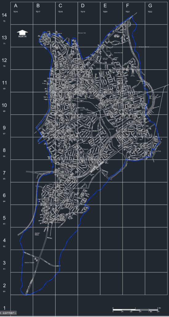
ACTION: Produced a skeletal borough map with local and national grid reference, which is useful for large scale projects and site location plans:
Produced a drawing highlight some roads as requested by the client:
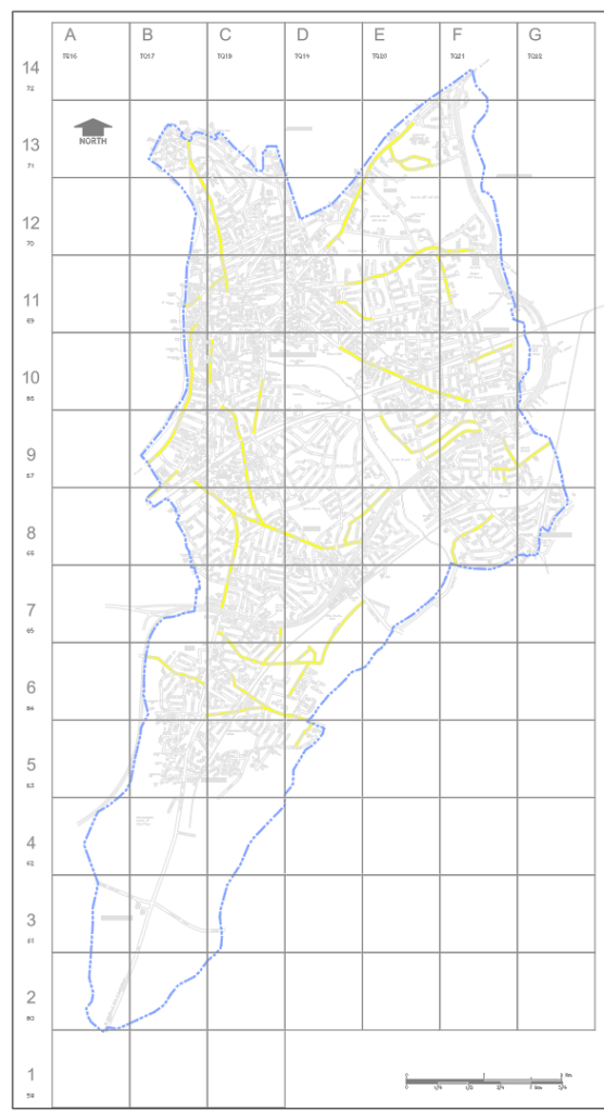
Client to provide a list of additional roads to be added in a different colour
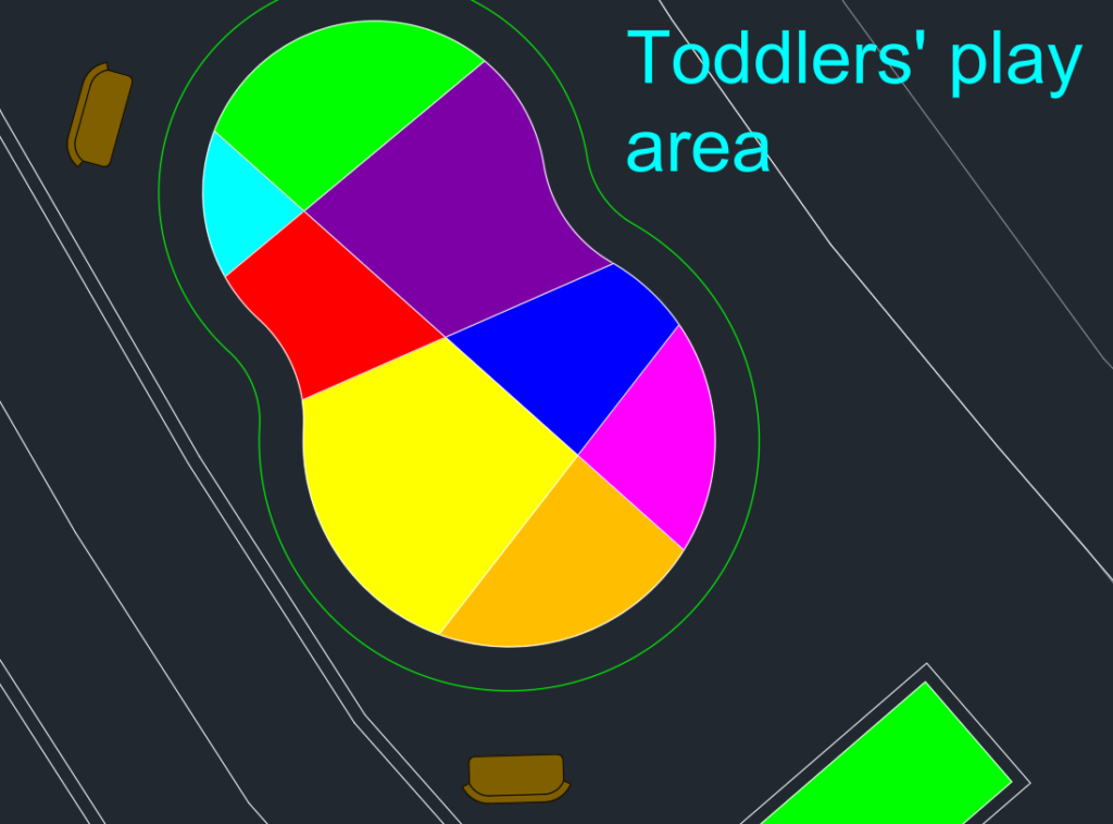
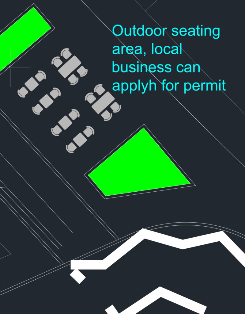
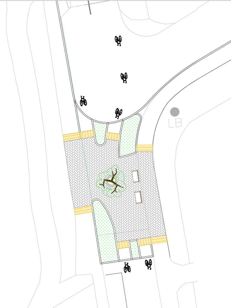
King Charles Road
Folder:
X:\RBK Kingston schemes\RBK Kingston schemes\Design Services\01 Project documents\RBK-30000 LIP Projects\RBK-30030 King Charles Road – Public Realm Improvement
X:\RBK Kingston schemes\RBK Kingston schemes\Design Services\01 Project documents\RBK-30000 LIP Projects\RBK-30030 King Charles Road – Public Realm Improvement\08_CAD\DWG Files\Feasibility Design
Coordinates:
51.387420097395, -0.29169474664668
ACTION: Initially the scope, scheme background, available/expected funding, client ambitions etc were not clear. Had detailed meeting with the client a week ago to understand what was required.
Advised the client of potential access requirements if the street was to be closed for a public realm project.
Did site visit and investigated further to establish the local needs. It was determined that what appeared to be a residential garage with a crossover (agreed by the client) was no longer a garage and access was not required. Had a discussion with a local business who were using some free parking spaces available in that section of the road, told them about the scheme and they expressed willingness to give up the free parking space in favour of a public realm scheme, but requested access for deliveries. It also came to light that another access over a waterway was required by the Environment Agency – they have cameras installed there and send lorries to clean up when required. Access for them can be maintained through a FS padlock as they have the same type of lock on their gate. Will need to be included in the consultation process.
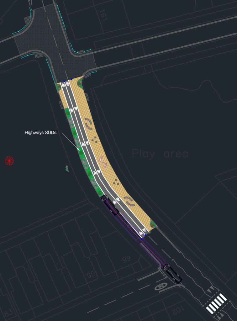
Advised Cagla to produce a drawing based on the above, and she has produced a design from that:
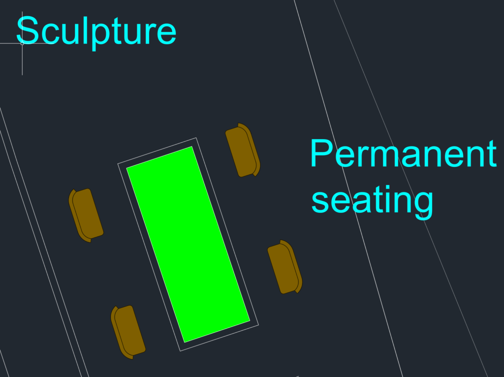
HA also produced a more elaborate drawing (work in progress) showing different elements that are possible to be incorporated in that space and taken to consultation to narrow down the choices:


To be discussed with the client if we are going in the right direction.
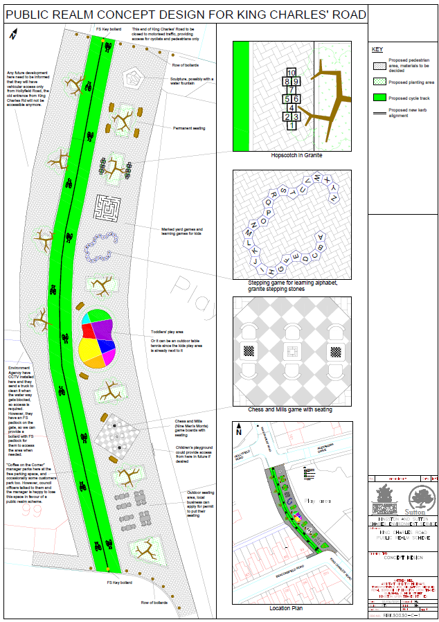
Provided the above design, and cost estimate from FMC to Younes for taking to the committee and bidding.
North Kingston Healthy Streets Phase 2
Folder:
X:\RBK Kingston schemes\RBK Kingston schemes\Design Services\01 Project documents\RBK-30000 LIP Projects\RBK-30008 North Kingston Healthy Streets Phase 2\
Coordinates:
51.4194465, -0.3045362
Lower Ham Road
ACTION: Initially the scope, scheme background, available/expected funding, client ambitions etc were not clear. Had detailed meeting with the client a week ago to understand what was required. Made a site visit with Pratik to take site measurements and to see the local conditions, figured out that some build-outs shown on OS maps weren’t present on site, changing the vehicle tracking requirements.
Produced the drawing below for this location:
Asked Pratik to put key and titleblock on it:

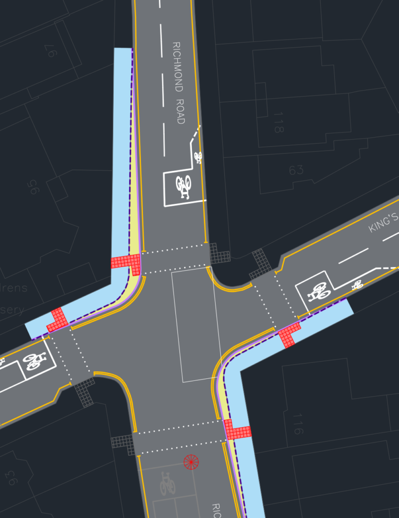
Richmond Road
ACTION: Initially the scope, scheme background, available/expected funding, client ambitions etc were not clear. Had detailed meeting with the client a week ago to understand what was required. Made a site visit with Pratik to take site measurements and to see the local conditions, figured out what could be done to improve the current narrow footway at pedestrian crossing.
This location didn’t have a simple solution. After considering several options, it was decided that the only way to widen the footway would be remove the right filter lane from the northern arm – the western arm is a no-through road so it has low traffic and it is expected that occasional right turning vehicles won’t impede the south-bound traffic too much. Pratik has produced a drawing for this:
JC
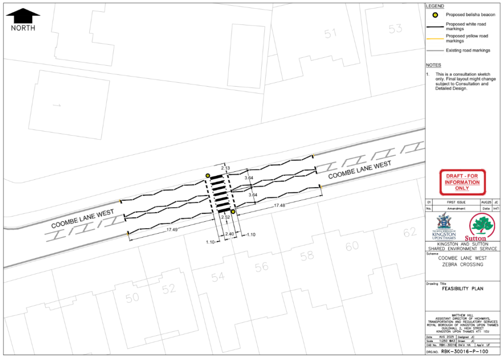
Coombe Lane West Zebra Crossing
ACTION: Suggested initial location for the zebra crossing and JC produced a drawing:
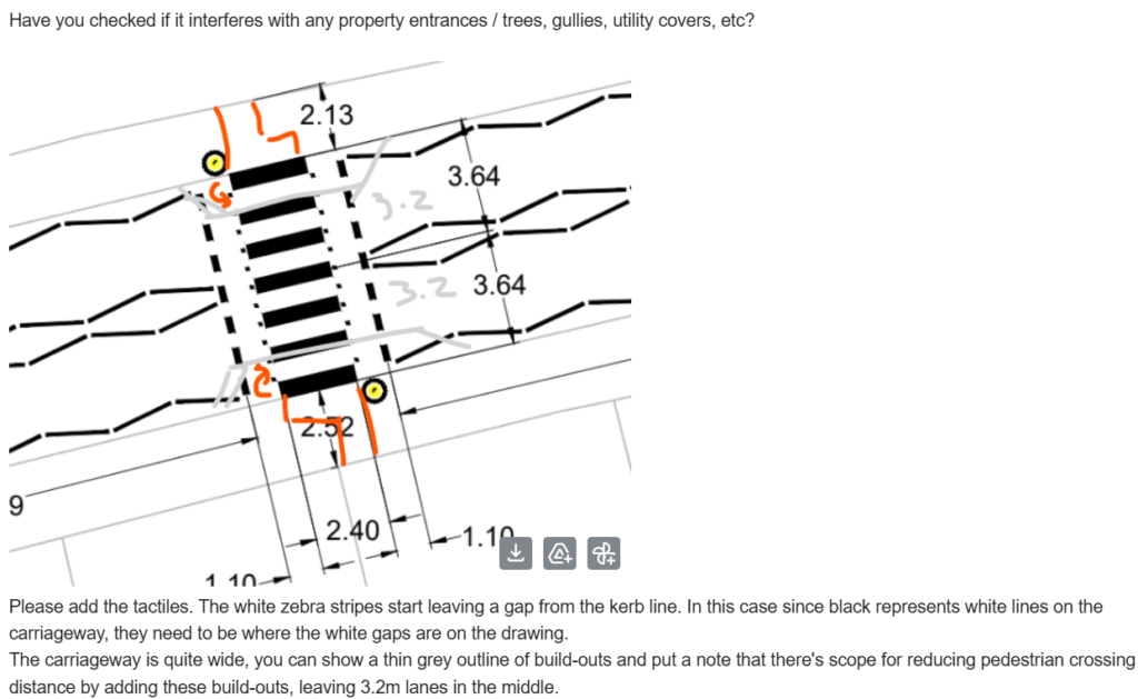
Then advised JC to add some missing elements etc:
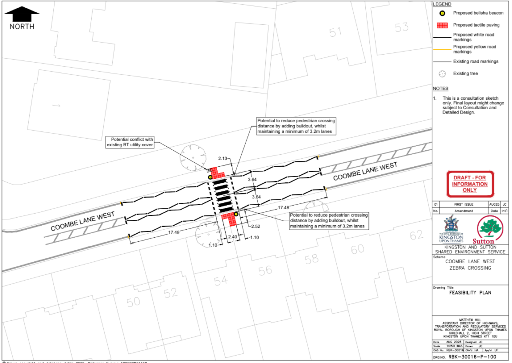
JC has produced a revised drawing, and also advised that the location is okay for adding build-outs if desired:
Pratik
Brighton Road Surbiton – 20mph Roundels
Folder:
X:\RBK Kingston schemes\RBK Kingston schemes\Design Services\01 Project documents\RBK-90000 Lining & Signing (Minor Scheme)\RBK-90034 20mph Roundel Brighton Road Surbiton
Coordinates:
51.390986, -0.308688
ACTION: Pratik hasn’t shared details of this scheme yet.
Green Wrythe Lane Corridor
Folder:
X:\LBS Sutton schemes\D&D\Projects\LBS-30000 LIP Projects\LBS-30004 Green Wrythe Lane Corridor
Coordinates:
51.372772, -0.168162
51.376614, -0.170093
51.377535, -0.170482
51.384628, -0.174103
ACTION: Pratik hasn’t shared details of this scheme yet.
H-Bar marking various locations
Folder:
X:\RBK Kingston schemes\RBK Kingston schemes\Design Services\01 Project documents\RBK-90000 Lining & Signing (Minor Scheme)\RBK-90033 H-Bar marking various locations
Coordinates:
Various – X:\RBK Kingston schemes\RBK Kingston schemes\Design Services\01 Project documents\RBK-90000 Lining & Signing (Minor Scheme)\RBK-90033 H-Bar marking various locations\01_Commission Brief
ACTION: Pratik hasn’t shared details of this scheme yet.
High Street, Kingston – RBK Cycle Routes
Folder:
X:\RBK Kingston schemes\RBK Kingston schemes\Design Services\01 Project documents\RBK-90000 Lining & Signing (Minor Scheme)\RBK-90027 RBK Cycle Routes – High Street, Kingston
Coordinates:
51.408947, -0.306302
ACTION: Pratik hasn’t shared details of this scheme yet.
Legible London, way finding signs
Folder:
X:\RBK Kingston schemes\RBK Kingston schemes\Design Services\01 Project documents\RBK-90000 Lining & Signing (Minor Scheme)\RBK-90043 Legible London, Way finding signs
Coordinates:
51.41262, -0.30103
ACTION: Pratik hasn’t shared details of this scheme yet.
Malden Road and Idmiston Road Parking Restrictions
Folder:
X:\RBK Kingston schemes\RBK Kingston schemes\Design Services\01 Project documents\RBK-90000 Lining & Signing (Minor Scheme)\RBK-90025 Malden Road and Idmiston Road Parking Restrictions
Coordinates:
51.384916, -0.251875
ACTION: Pratik hasn’t shared details of this scheme yet.
Manorgate Road Width Restriction
Folder:
X:\RBK Kingston schemes\RBK Kingston schemes\Design Services\01 Project documents\RBK-40000 Non LIP Projects\RBK-40028 Manorgate Road Width Restriction
Coordinates:
51.413783, -0.284904
ACTION: Checked Pratik’s drawings, and provided the client detailed feedback from personal experience of driving through this road. Based on the feedback, the client agreed to consider another design option, for which the drawing has also been produced.
Ridge Road Zebra Crossing
Folder:
X:\LBS Sutton schemes\D&D\Projects\LBS-30000 LIP Projects\LBS-30003 Ridge Road Zebra Crossing
Coordinates:
51.380465, -0.215002
ACTION: Pratik hasn’t shared details of this scheme yet.
Surbiton Road – new parking sign
Folder:
X:\RBK Kingston schemes\RBK Kingston schemes\Design Services\01 Project documents\RBK-90000 Lining & Signing (Minor Scheme)\RBK-90036 New Parking Sign on Surbiton Road
Coordinates:
51.401743, -0.304419
ACTION: Pratik hasn’t shared details of this scheme yet.
Sutton High Street and Oakhill Road Safety Scheme
Folder:
X:\LBS Sutton schemes\D&D\Projects\LBS-30000 LIP Projects\LBS-30005 Sutton High Street and Oakhill Road Safety Scheme
Coordinates:
51.371333, -0.194623
ACTION: Pratik hasn’t shared details of this scheme yet.
Thomas
Collingwood Road 7.5T
X:\LBS Sutton schemes\D&D\Projects\LBS-30000 LIP Projects\LBS-30027 Collingwood Road 7.5t HGV Ban\02_Project Management\TFL Approvals
X:\LBS Sutton schemes\D&D\Projects\LBS-30000 LIP Projects\LBS-30027 Collingwood Road 7.5t HGV Ban\08_CAD\Issued PDF Drawings\15-07-2025 TfL HAD Submission
ACTION: Had a meeting with TfL along with Thomas to address the issues raised by TfL and get it to construction stage.
Jubilee Way
Folder:
X:\RBK Kingston schemes\Design Services\01 Project documents\RBK-50000 Cycle Route Projects\RBK-50004 Jubilee Way
Coordinates:
51.371397, -0.283886
ACTION: Had several meetings with Thomas, Umer, then with the client team, with JC etc. Highlighted the issues with the original design. Client explained the reasoning behind the odd design – mainly approval from the committee, and not being allowed to remove some trees for a new cycle path. JC has now produced an option.
Viral
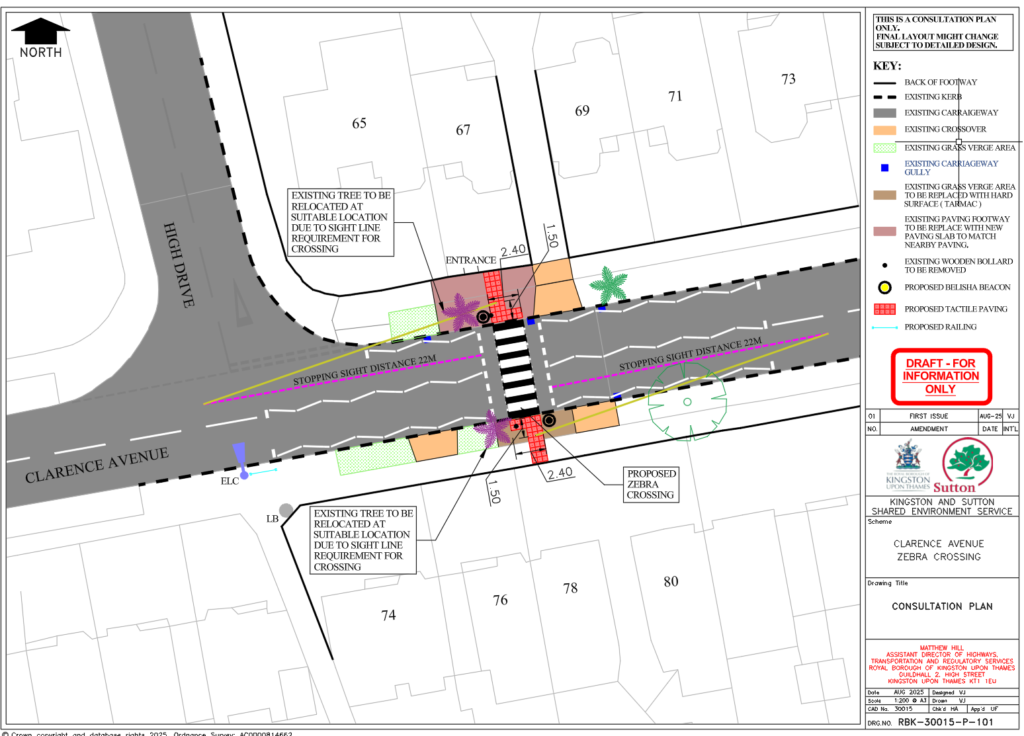
Clarence Avenue Zebra Crossing
Folder:
X:\RBK Kingston schemes\Design Services\01 Project documents\RBK-30000 LIP Projects\RBK-30015 Clarence Avenue Zebra Crossing
Coordinates:
51.4091477, -0.2691023
ACTION: Did site visit with Viral, assessed the options, took site measurements so that a topo survey is not required anymore that Viral wanted.
Viral drafted a revised drawing:
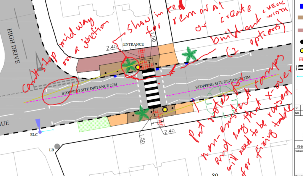
Then Viral has produced a drawing, to be approved by Umer:
Kingston Academy Pedcycle lane Crossover
Folder:
X:\RBK Kingston schemes\Design Services\01 Project documents\RBK-40000 Non LIP Projects\RBK-40031 Kingston Academy Pedcycle lane Crossover
Coordinates:
51.423818756532, -0.3036757845044
ACTION: Viral wanted a topo survey for this site. Advised that it is not required for this scheme. Did a site visit with Viral and FMC. Determined that it won’t be feasible to lower the utility cover because it’s a plastic box, hence it won’t be cheap to bring a cycle path straight over it due to sharp ramp required after that:
Now the options are:
- Spend money to get the utility cover lowered to put a cycle path as requested by the client – shown in red
- bifurcate the in and out lanes to avoid the utility cover – shown in green
- utilise the existing crossovers by creating a shared path along the footpath between the existing crossovers for the school, may need to widen the crossovers if desired – shown in orange
Langley Road zebra crossing
Folder:
X:\RBK Kingston schemes\Design Services\01 Project documents\RBK-30000 LIP Projects\RBK-30018 Langley Road – Zebra Crossing
Coordinates:
51.388168679277, -0.29930275945715
ACTION: Original option as requested by the client had an odd arrangement of the carriageway narrowing down to a single lane at the crossing while having two lanes at the approach zigzags and the crossing width was too narrow (2.1m):
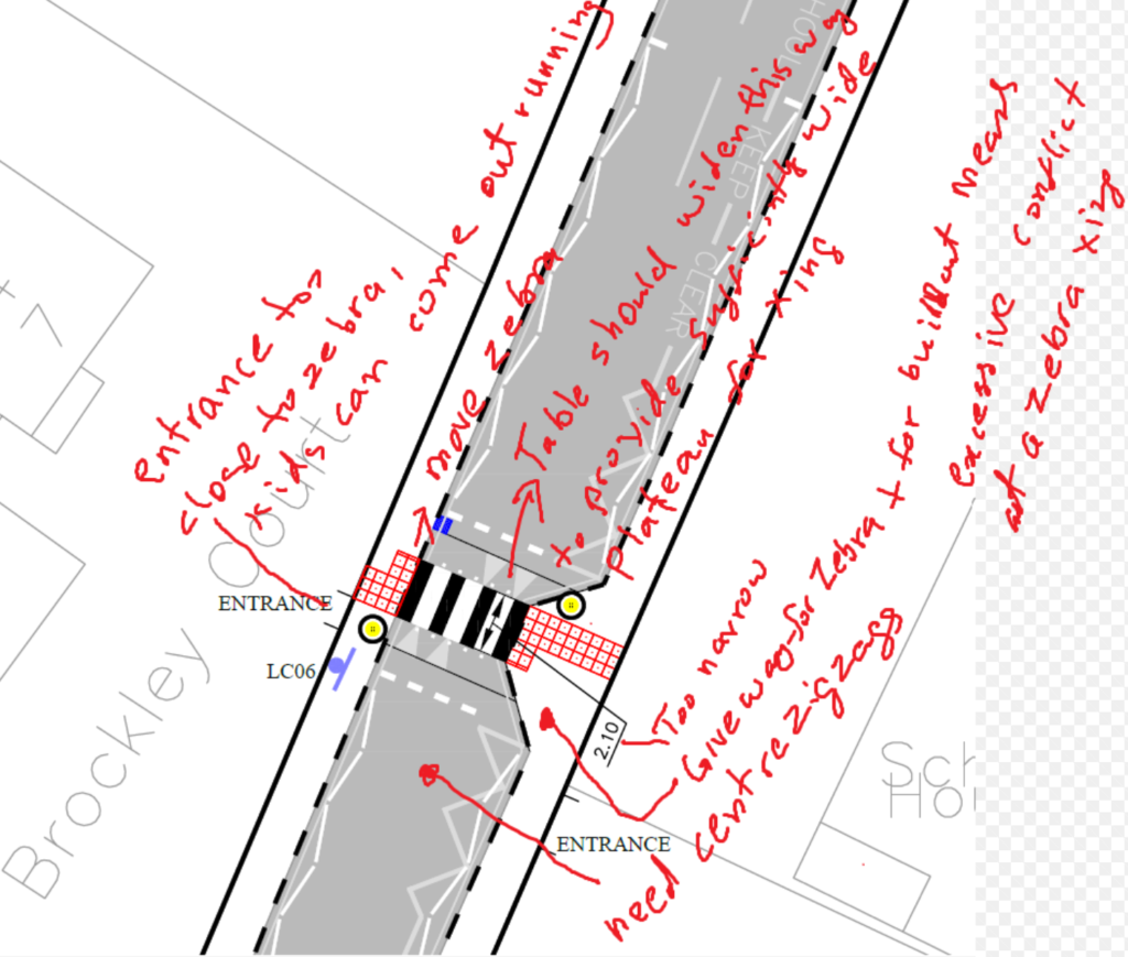
Then produced another option where the build-out was removed. Even though the footway is narrow, the carriageway is also only 6m wide, that’s why didn’t add any build-outs.
Then Umer advised to have build-outs to widen the footway at the crossing, leaving about 4.6m wide carriageway:

Powershell
dir *.dwg | select name >filenames.txt
251 total views, 1 views today